

Known for its magnificent architecture, cultural heritage and religious sites, Cairo has a rich history dating back to the 10th century AD. However, the city’s long reign as Egypt’s capital is coming to an end. As has happened many times in the country’s past, the seat of national government is being relocated, this time to a brand new city in the desert, 45 kilometers east of Cairo.
Faced with the increasing population, congestion and pollution in Cairo, the government announced in 2015 that it would build and relocate the so-called new administrative capital (the city does not yet have an official name). It is estimated that by 2024, more than 22 million people will live in Cairo, giving a population density of more than 19,000 people per square kilometer. The new city will ultimately cover an area the size of Singapore, house more than six million residents and include Egyptian government offices, a financial district and other facilities.
By March 2024, more than 1,500 families had moved to the city, according to news reports, and that number is expected to rise to 10,000 by the end of the year. Ministries were relocated, parliament met in its new building, and several banks and companies were scheduled to move their headquarters there.
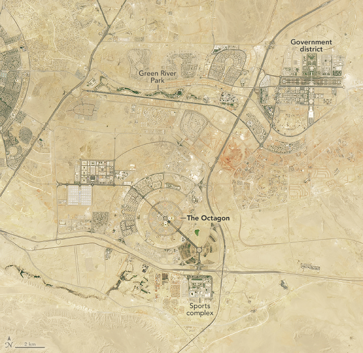
These images of the new capital were taken by the OLI (Operational Land Imager) on Landsat 8 (left) and the OLI-2 on Landsat 9 in August 2017 (left) and August 2024 (right), respectively. In the earlier image, traces of the city can be seen; work on the mega-project had already begun by then. In the later image, the expansion of the new administrative capital is clearly visible.
Several major landmarks of the new capital are clearly visible in the images. A winding green space, part of Green River Park, stretches 10 kilometers through the arid landscape and features walking and cycling trails as well as native Egyptian vegetation. Many ministries occupy the dense development to the east of the park, while the Defense Ministry occupies a large complex called the “Octagon” (despite its concentric circle in this image). To the south is a sports complex that includes Africa’s second largest stadium and numerous other sports facilities. Egypt is reportedly planning a bid to host the Olympic Games.
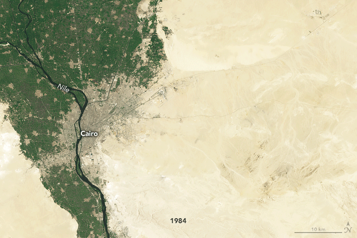
Cairo, one of Africa’s largest cities, has experienced major expansion over decades. Urban growth has been documented from space since 1965 and NASA’s Gemini 5 mission. More recently, Landsat satellites have mapped Cairo’s expansion and the construction of other new, outlying cities. The time series above shows how Greater Cairo changed every 10 years between 1984 and 2024.
Cairo’s population has grown from about 8 million to over 22 million since 1984, and this near tripling of the population has dramatically changed the layout of the city. In addition to building upwards and outwards on the fertile Nile floodplains, development has spread to several new satellite cities built on desert plains outside the city. About 95 percent of Egypt’s population lives within 20 kilometers of the Nile and its delta and depends on its fertile land and water. With increasing domestic and agricultural needs, the country is likely to import more water than the Nile supplies by the end of this decade, according to one forecast.
NASA Earth Observatory images by Michala Garrison using US Geological Survey Landsat data. Story by Lindsey Doermann.
