
A true, color global Mars image map in Robinson projection is created from the MoRIC image data from Tianwen-1. The resolution of the original data is about 76 m per pixel and the horizontal accuracy is 68 m. Image credit: Science China Press
Remote sensing images of Mars contain rich information about its surface morphology, topography and geological structure. These data are vital for scientific research and Mars exploration missions. Before China’s first Mars exploration mission, data from six advanced optical imaging systems of various Mars orbiting missions were used to create global/near-global image datasets of Mars with spatial resolutions better than 1 km.
However, in terms of global color images, the best version of Mars Viking Colorized Global Mosaic has a resolution of about 232 m/pixel. Global color images of Mars at hundred-meter scale and higher resolution are missing.
New data from the Tianwen-1 mission has laid the foundation for the development of a high-resolution global color image map of Mars with high positioning accuracy. As of July 25, 2022, the Tianwen-1 Moderate Resolution Imaging Camera (MoRIC) had completed 284 orbits during its remote sensing mission and acquired 14,757 images with spatial resolutions between 57 and 197 m.
The collected images covered the entire surface of Mars. Almost simultaneously, the Tianwen-1 Mars Mineralogical Spectrometer recorded a total of 325 data strips in the visible and near-infrared range, with spatial resolutions of 265–800 m.
Using the above data, Professor Li Chunlai of the National Astronomical Observatory of the Chinese Academy of Sciences and Professor Zhang Rongqiao of the Lunar Exploration and Space Engineering Center led the Tianwen-1 science team and its collaborators in conducting research on image data processing and global mapping of Mars. The research work was published in the journal Science Bulletin.
-
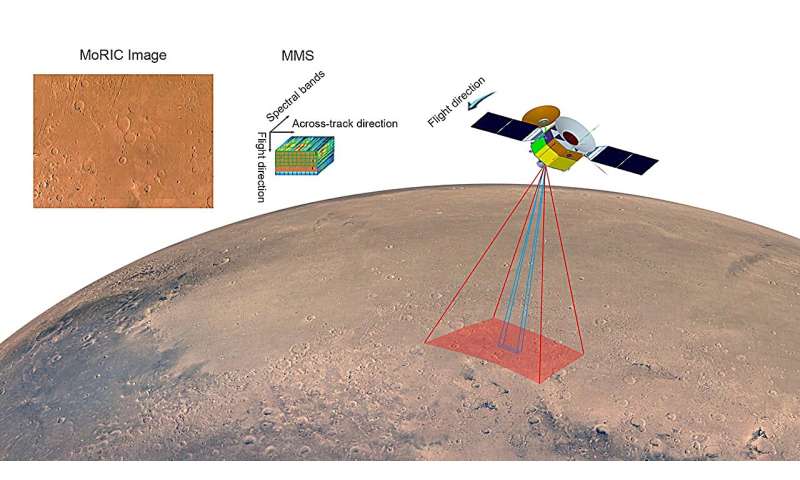
Remote sensing images of the entire Martian surface were captured using the optical camera (MoRIC) and imaging spectrometer (MMS) on board the Tianwen-1 orbiter. Image credit: Science China Press
-
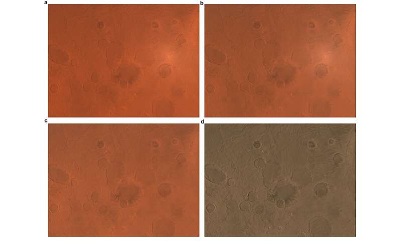
(a) Level 2C data product as input, (b) image corrected by atmospheric correction, (c) image corrected by photometric correction, and (d) image corrected after color correction. Source: Science China Press
In this study, bundle adjustment technology was used to optimize the original orbital measurement data, treating Mars as a unified adjustment network, reducing the positional deviation between individual MoRIC images to less than 1 pixel and achieving a “seamless” global image mosaicking at the pixel level.
Brightness and color consistency of the global images were ensured by color correction and global color uniformity. The true colors of the Martian surface were measured using the MMS onboard the Tianwen-1 orbiter, and a true color reference for the Martian surface was created to restore true colors.
As part of this study, a global color image dataset and map of Mars (Tianwen-1 Mars Global Color Orthomosaic 76 m v1) with a resolution of 76 m and a horizontal accuracy of 68 m were created and published.
The Tianwen-1 Mars Global Color Orthomosaic data products fill the gap in high-precision positioning of global Mars color image data products at a scale of tens of meters. It is currently the highest-resolution global true color image map of Mars and greatly improves the resolution and color authenticity of commonly used global Mars images.
This mapping product can serve as a new global basemap of Mars and provide a higher quality geographic reference for international colleagues to conduct image mapping of Mars at scales of tens of meters, meters and submeters, and further support subsequent Mars exploration missions and scientific research.
Further information:
Jianjun Liu et al., A 76 m per pixel global color image dataset and map of Mars from Tianwen-1, Science Bulletin (2024). DOI: 10.1016/j.scib.2024.04.045
Provided by Science China Press
Quote: Research team releases 76 m per pixel global color image dataset and map of Mars (15 August 2024), retrieved 15 August 2024 from https://phys.org/news/2024-08-team-pixel-global-image-dataset.html
This document is subject to copyright. Except for the purposes of private study or research, no part of it may be reproduced without written permission. The contents are for information purposes only.
